HISTORIC ARCHIVE
LITTON CHENEY CENSUSES
A census is taken every 10 years. Those currently available for public viewing cover the period 1841 to 1911 – data is only made
available after 100 years have passed. Each household is required to complete a census return on a particular night. Thus, it merely
provides details of who was present on that day, not necessarily of everybody who normally lives there. The data requested varies at
each census, more information being available from the later ones. However, except for major dwellings such as the church, the
school, larger houses and farms, there is no record of the actual location of each dwelling.
The boundaries of Litton Cheney Parish have been manipulated at various times during the period covered by available census data.
The following lists are taken from the introduction of each census.
1841 - View transcription see analysis below
1851 - Covers the whole of the Parish of Litton Cheney including Loder Lands Farm, Eggardon, Stancombe Charitys, Gorwell, Ashley, Parks and
Litton Cheney Village.View transcription
1861 - Covers the whole of the Parish of Litton Cheney including Loder Lands Farm House, Eggardon Farm House, Dairy House and Cottages,
Stancombe Cottages, Combe Farm House, Dairy House and Cottages, Litton Cheney Village and Charitys, Parks Dairy House, Ashley Dairy
House and Cottages, and Gorwell Farm House and Cottages.View transcription
1871 - Covers the whole of the Parish of Litton Cheney including Litton Cheney Village, Loder Lands Farm Houses, Eggerton, Stancombe,
Charitys, Gorwell, Ashley, Parks, White Cross and Combe Farm House and Cottages. View transcription
1881 - The whole of the Parish of Litton Cheney including Litton Cheney Village, Loder Lands Farm Houses, Eggerdon Farm House
and Cottages, Stancombe Cottages, Charitys, Gorwell Farm House and Cottages, Ashley Dairy House and Cottages, Parkes Dairy-
House, White Horse, Coombe Farm House and Cottages.View transcription
1891 - The whole of the Parish of Litton Cheney is bounded on the West by Chilcombe, on the North by Askerswell, on the South by
Puncknowle and on the East by Abbotsbury.
It includes Litton Cheney Village, Stancombe Cottages, Gorwell Farm House and Cottages, Ashley Dairy House and Cottages,
Parkes Dairy House, the White Horse Inn and Coombe Farm House and Cottages. Unfortunately the census document does not
show addresses.View transcription
1901 - The whole of the Parish of Litton Cheney is bounded on the West by Chilcombe, on the North by Powerstock and the Old
Roman Road, on the South by Puncknowle and Swyre and on the East by Long Bredy.
It includes the Parish of Litton Cheney, Stancombe Cottages, Coombe Farm House and Cottages, the White Horse Inn, School
House and Cottages. Unfortunately the census document does not always show addresses.View transcription
1911 - The whole of the Parish of Litton Cheney is bounded on the West by Chilcombe, on the North by Powerstock and the Old
Roman Road, on the South by Puncknowle and Swyre and on the East by Long Bredy.
It includes the Parish of Litton Cheney, Stancombe Cottages, Coombe Farm House and Cottages, the White Horse Inn, School
House and Cottages.View transcription
THE PASSING YEARS
The following are links to newspaper articles covering various aspects of life in Litton Cheney over nearly 200 years. Plus ça
change, plus c'est la même chose!
Life and Death
Deeds and Mis-deeds
Life in Wartime
Paul Kingston has compiled the following diaries covering every-day life in Litton Cheney during the First and Second world wars:
ABOUT LITTON CHENEY

The 1841 census gives no schedule numbers, no indication of relationship and ages over 15 years are rounded to the
nearest five years. Like all censuses, it is merely a list of names and occupations giving no idea of who owns and occupies
the land and buildings within the parish. The 1841 version is different, however, as it can be cross-referenced to the 1840
tithe map and associated apportionment. A transcription of the modified data can be viewed here. The associated tithe
apportionment can be viewed here
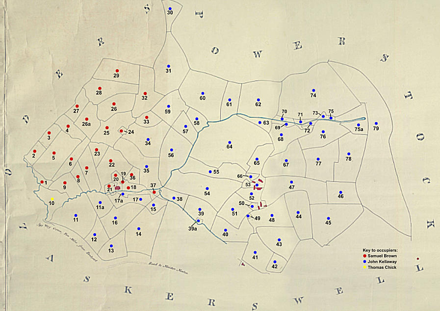
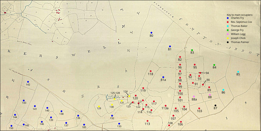
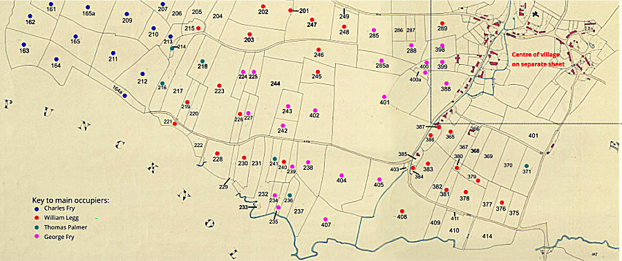
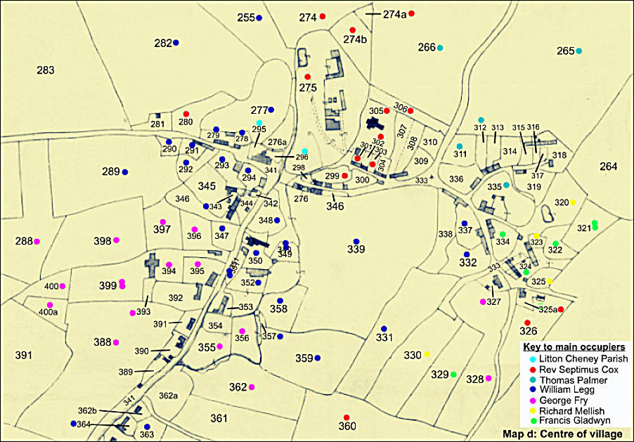
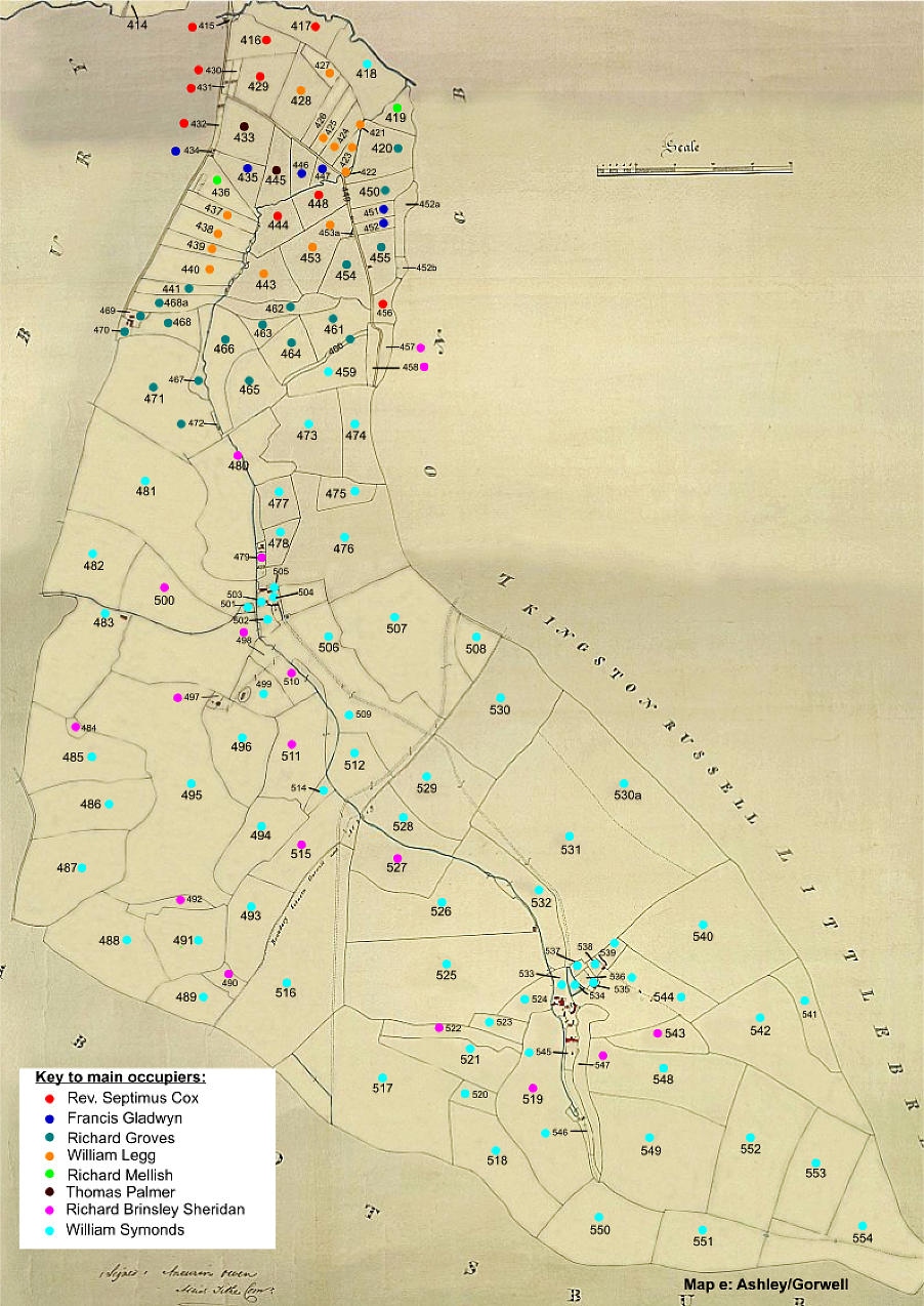
The parish of Litton Cheney was much larger than it is today stretching to the Roman road to the north, Gorwell to the south east
and an entirely separated area between Askerswell and Powerstock known as Loder Lands. For ease of display, the tithe maps
below have been divided into five sections:
a.
Loders Land
b.
Area north of the Dorchester to Bridport main road
c.
Area south of the Dorchester to Bridport main road
d.
Litton Cheney village
e.
Ashley & Gorwell
Occupiers of the land and buildings are denoted by coloured markers. The following table shows the main occupiers of the 581
plots identified within the tithe apportionment.
No. Plots
No. Acres
Name
Owned
Occupied
Owned
Occupied
Remarks
Richard Brinsley Sheridan Esq.
101
18
1179
148
William Legg
84
81
376
353
Walter Long Esq.
79
0
840
0
Rev Charles Fryer
59
0
426
0
Rev. Septimus Cox
45
72
143
500
Samuel Brown
23
26
100
100
All in Loders Land
Blandford Charity
22
0
164
0
Rev. Gregory Raymond
20
0
140
0
George Fry
18
33
35
177
18 plots owned by Bradford Charity
Charles Henvele Esq.
18
0
84
0
Francis Gladwyn
15
16
17
18
Richard Groves
15
23
86
114
Elizabeth Hansford
9
0
56
0
Charlotte Hunter
7
0
54
0
Parish of Litton Cheney
6
5
10
5
Includes chalkpit, sandpit, Poor House and Pound
Richard Fowler
2
0
80
0
William Symonds
0
68
0
958
All plots owned by Richard Brinsley Sheridan Esq.
Charles Fry
0
78
0
830
All owned by Walter Long esq.
John Kellaway
0
55
0
425
All in Loders Land; owned by Rev. Charles Fryer
Thomas Palmer
0
15
0
100
Thomas Baker
0
2
0
80
Plots owned by Richard Fowler
Richard Mellish
0
14
0
65
All plots owned by Charles Envele Esq.

1841 CENSUS RELATED TO THE 1840 TITHE MAP
**Note:
1901 and 1911 scholar totals estimated from children’s ages i.e. 5 to 13 which was the
compulsory period for education, although difficult to enforce. In 1841 there were 70+
children between the ages of 5 and 13 but no compulsory education.
Families
It is interesting to see how many names crop up during the period covered. Some families appear on as many as seven censuses
and may continue after the 1911 version. The table HERE lists those that appear on at least two censuses.
Map a: Loder Lands
Part of Loder Lands
Map b: North of A35

Map c: Souh of A35
Part of Ashley/Gorwell
LITTON CHENEY CENSUSES


Occupations
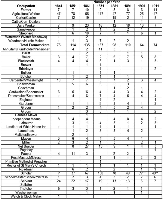
The table below summarises the occupations of Litton Cheney residents during the period covered. As one would expect, the
majority were involved with various types of farm-work. However, many now defunct (as far as the village is concerned)
occupations are listed e.g. cordwainer, brewer, baker, harness maker and, in particular, servant.
Analysis of 2021 Census Results
2021 CENSUS RESULTS ANALYSIS
An analysis of the 2021 Census results, which as carried out by the Bridport Local Area Partnership, creates valuable
evidence about the area and its needs.
Key findings for the Parish and Town Councils within the Partnership’s area are that, when compared with Dorset as a
whole and with England as a whole:
They have a high proportion of older residents who are aged 65 or over;
They have a low proportion of young adult residents who are aged 20 to 34;
They have a high proportion of working residents who work part-time;
Roughly a fifth of residents have a disability or long-term health issue which limits their day-to-day activities;
Roughly a tenth of residents are providing regular, unpaid care for someone else
Levels of car ownership are generally high, reflecting the paucity of public transport and the journeys often required
to reach jobs or services.
The findings from this analysis have real world implications for the area. For example, the economic impact from losing
many young adults and their skills, the demand placed upon health and care services from an ageing population and the
isolation faced by some who don’t have access to a car (especially where there is no alternative transport option).
Whilst some of these findings may come as no surprise to local people, it is hoped that having accurate and up-to-date
figures will prove useful as evidence to make the case for local service improvements and to support bids for grant
funding.
Census results for individual Parish and Town Council areas can be found in the full report which is available at this
webpage https://www.bridport-tc.gov.uk/bridport-area-census-profile/
Further information
Older age groups: all fourteen Parish and Town Councils in the Partnership’s area have a high proportion of residents
aged 65 or over. Parishes with the highest proportion are Burton Bradstock (48% of all residents), Chideock (47%) and
Charmouth (46%). The comparable figure for England is 18% and for Dorset 30%.
Young adults: all Parish and Town Councils in the Partnership’s area have a low proportion of residents aged 20 to 34.
Parishes with the lowest proportion are Bothenhampton & Walditch, Burton Bradstock, Charmouth, Char Valley and
Chideock (in each case 8% of residents). The comparable figure for England is 20% and for Dorset 13%.
Part-time working: another notable feature is the high proportion of working residents in the Partnership’s area who work
part-time. Parishes with the highest proportion are Chideock (46%), Bothenhampton & Walditch (45%), Symondsbury
(45%), Char Valley (43%) and Allington (43%). The comparable figure for England is 30% and for Dorset is 35%.
Health and care: parishes with the highest proportion of residents with a disability or long-term health issue which limits
their day-to-day activities are Bridport (24%), Charmouth (24%) and Bradpole (22%). Proportions for this measure and for
residents who provide regular, unpaid care to someone else are quite high by comparison with England as a whole.
Car ownership: car ownership is generally high in the Partnership area. The most rural Parishes have the highest
proportion of households with a car – notably Netherbury, Char Valley, Litton Cheney and Shipton Gorge. An exception is
Bridport (town) where almost a quarter of households (24%) have no car.
Other topics covered by this 2021 Census analysis include home ownership and renting, employment and unemployment,
qualifications held by residents and working from home.
The Bridport Local Area Partnership is a network with around 80 member organisations or groups from the public, private
and voluntary sectors. They include Bridport Town Council and thirteen nearby Parish Councils (see list below). The
2021 Census shows that 21,780 people live in this area, very similar to the count ten years earlier by the 2011 Census.
A Census has usually been held every ten years, run by the Office for National Statistics, to count the population and
measure its characteristics right across England and Wales. Analysis by the Bridport Local Area Partnership focusses on
findings for the Parish and Town Councils within its area, showing variation between them and making comparison with
Census figures for the whole of Dorset and whole of England.
The following Parish and Town Councils are members of the Partnership:
Allington Parish Council
Bradpole Parish Council
Bothenhampton and Walditch Parish Council
Bridport Town Council
Burton Bradstock Parish Council
Charmouth Parish Council
Char Valley Parish Council
Chideock Parish Council
Litton Cheney Parish Council
Loders Parish Council
Netherbury Parish Council
Puncknowle and Swyre Parish Council
Shipton Gorge Parish Council
Symondsbury Parish Council


FOOTNOTE
An interesting statistic that has been missed from the BLAP analysis is the fact that Litton apparently has within its confines
the brightest and best qualified inhabitants in the Bridport and Lyme Regis area - see below - and it would appear, the rest of
Dorset, and England.
Allington a) 28% b) 16% c) 22%
Bothenhampton & Walditch 37% 16% 34%
Bradpole 31% 16% 29%
Bridport 30% 20% 26%
Burton Bradstock 38% 14% 40%
Charmouth 37% 14% 34%
Char Valley 38% 13% 31%
Chideock 35% 17% 34%
Litton Cheney a) 54% b) 8% c) 46%
Loders 37% 10% 34%
Netherbury 37% 13% 33%
Puncknowle & Swyre 39% 10% 34%
Shipton Gorge 37% 16% 30%
Symondsbury 36% 14% 34%
Dorset (county) 32% 16% 32%
England 34% 18% 33%
KEY:
a) Proportion qualified to degree level, b) Proportion with no formal qualifications, c) Proportion in managerial or professional
occupations
VILLAGE APPRAISAL c.1985
In 1985 the Village Society carried out an informal appraisal in order to ascertain the state of the village population-wise. Purely as
amatter of interest, the results can be read here


