WDDC APPRAISAL OF LITTON CHENEY
Spatial Analysis
The character and interrelationship of spaces within the Conservation Area
The village is set below the high escarpment edge of the South Dorset chalk downs,
on a shelf above the Bride valley to the south, more or less on a spring line where
several watercourses emerge from the slopes and flow south to the main river. The
village has an interesting plan form, being arranged around an approximate
rectangle of lanes, with a hollow
undeveloped core. From the south, White
Cross is an outlier, with the White Horse
Inn and a Youth Hostel. Main Street runs
north (forming one side of the rectangle),
with a ribbon of old buildings, including the
Mill, Court House and new infill. School Lane runs off east (the base of the
rectangle), with Court Farm at the corner and later Thorner’s School and a few
modern large individual houses.
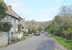
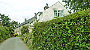
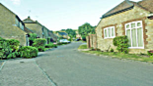
Main Street becomes known as Redway as it turns the corner eastwards at the
western crossroads, with Chalk Pit Lane running west in a short ribbon, Watery
Lane north as an undeveloped track, and a narrow west-east lane extending past
the Parish Church and Old Rectory, both of which are set on a higher level and are
connected to the main route by two paths: Rocks from the west and Church Path
from the east, both meeting by the entry to the big house and the churchyard. A
northern lane, Whiteway, runs from the west-east lane steeply uphill into the chalk
slopes towards the turnpike road (present A35). Beyond Whiteway, Redway
becomes Main Street again and turns SE (with its ribbon of building and two cul-de-
sacs to the east), forming a junction with Hine’s Mead Lane, but then continues
eastwards past Baglake Farm on towards Long Bredy. Development stops half way along Hine’s Mead Lane, which then
passes the eastern end of School Lane.
Webmaster’s Note: This is not strictly true. There is development at The Mount, at the eastern end of School Lane.
This pattern of lanes has a ribbon of building, then a minor focus around the
western cross roads (where the village poor house and pound were once sited),
then an undeveloped gap backed by the Church in an offset position, then
another ribbon with thickenings of development from Church Path to the Baglake
lane. This plan is not a pure ribbon, nor is it a strongly nucleated form, mainly
older development being only one plot’s depth from the access lanes. The plan
form is thus a long, angled ribbon with minor focal points at two junctions and a
more major focus in the centre and east of the northern lane, in the form of the
Church, former and current Rectory,
several former farms, sites of a shop and businesses like a brewery and forge
and a cluster of cottages. The extent of the village seems to have remained
static for much of the late C19 and early C20 (the 1888 and 1903 Ordnance
Survey sheets, for example, are identical). New development on a significant
scale has occurred since the 1970s, with infill closes west of Baglake Farm and
south of The Paddocks, in a ribbon along Chalk Pit Lane, as infill along Main
Street and as large individual plots along Hine’s Mead and School Lanes.
To give a fuller description of the village, it is possible to use some of the
principles of townscape described above during an east to west walk from
Baglake Farm to the lower end of Main Street. A west-east route would be
equally valid but the chosen route will describe views looking east (and
looking backwards) where appropriate.
The eastern approach from Long Bredy winds below the chalk hills to the
north, performs a sharp right angle, passes a long stone wall with an inset
stone arched entrance and arrives at the architectural splendours of Baglake
Farm, where long chalk block or cob boundary walls, with a stone rubble
base and thatched capping and a barn made of similar materials frame the
urbane classical front of the farmhouse, with its entrance canopy supported by richly scrolled brackets.
There are views of smooth chalk hills to the west, framed by hedges and trees and the lane then curves to the right, at the
junction with Hine’s Mead Lane, which is strongly marked by the projecting gable end
of Glebe Cottage, with conspicuous, large chalk blocks and a thatch half-hip. Turning
into the Lane, the full delights of Glebe Cottage are revealed, with the mixture of
materials and the undulating eaves and ridge of the roof. Opposite is a well-detailed
modern thatched cottage and looking back north between hedged boundaries to the
east-west lane, there is a view of a row of thatched cottages running off to the left
(west) and another view NW over a field to the Church tower and a mass of trees.
Back on the east-west lane, the terraced row (Barges
Farmhouse, Randell Cottage and Barges Cottage) has
differing thatched ridge heights and subtle differences
in casement window detail and doorways. Hedges and
railings bound front gardens and Barges Farmhouse has stone capped brick gate piers. The
row is firmly terminated by a cider house, which projects to the road line, showing its flank
constructed of varied materials. Opposite, on the left, Myrtle Cottage presents a gable end and
attractive shrubs in its front space and there is a partial view of another half-hipped gable end
up the lane, which is beginning to rise. It veers to the left, stone walls marking its outside edge
and big trees filling the horizon.
On the right, Brewery Cottages has another pleasant front space, without a boundary to the
lane and its projecting trellised porch is a minor landmark. Following the
rising, curving lane, another varied and handsome row curves round the
inside of the bend, stepping up to the gable end of Beech House. This house has splendid cast iron
railings and an attractive Gothic Revival porch (Fig.2), a visual highlight of the village. Opposite, a
rising lane (The Paddocks) curves round to the right, with a row of cottages on its northern side, a
detached house rising higher and then a final flourish in a surprising row set behind long front
gardens.
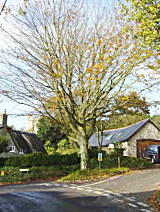
Back to the main route, the constant curve becomes sharper and the levels begin to fall by the
junction with Whiteway, where a small triangular green and a fine
beech tree lead the eye uphill into a deeply incised green lane.
Opposite a red telephone box is partly hidden by hedges and trees.
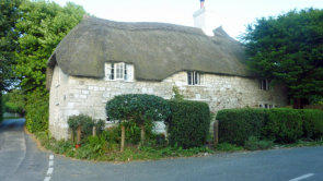
On the right, north, a handsome thatched row (Church Path Cottages) is elevated above a
raised stone pavement but is partly hidden behind hedges. Redway falls steeply downhill,
narrows and is overhung with hedges and trees, with only a hint of building on the right,
above high walls and hedges.
The alternative route at this point is up Church Path, a basically pedestrian lane past a
curving row of cottages, two more trellised porches and a sudden arrival at two
sets of stone gate piers, gates, hedges and stone steps. One entry leads to The
Old Rectory, which is hidden in a veritable woodland, and the other steps and
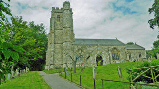
gate lead to the churchyard, where the Church is set high above, with its strong
western tower and projecting stair turret, southern flank and porch all exposed to
view.
There is the beautifully lettered Reynolds Stone gravestone in the western corner
and a glimpse of The Old Rectory through the hedge. Back to Church Path, a
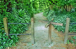
footpath named Rocks falls steeply, bounded by stone walls and hedges and
overhung by superb trees. The revolving turnstiles are unusual and add to the
sense of a lost world. The grounds of The Old Rectory have many specimen trees, two ponds and cascades. Rocks
suddenly falls into the main lane, by the flank of Court Cottage, with its unusual lozenge glazing bars (Fig.2).
The lane opens out into a wider space, created by a crossroads and marked by a thatched bus shelter, commemorative
seat, triangle of shrubs and a tree and a DCC finger post. To the north, Watery Lane is a muddy green track. West, Chalk Pit
Lane rises and curves past a large modern former engineering premises, a stone barn with its half-hipped gable to the lane
covered by corrugated metal sheet and a mixture of old and modern cottages and houses. Looking back east to the
crossroads, there is an uncontrived composition of cottages, stone walls, the bus shelter and huge trees. Turning right
(south) down Main Street, Court House’s walls and large trees are faced by a long group of old cottages to the right (west),
with the simple but attractive gable end of the former Chapel and then an organic row of cottages set behind a hedge and a
communal lawned space. The Cottage provides a grander termination, with a conspicuous white cast iron porch (Fig.2).
Court House’s Classical front is seen opposite between stone gate piers. The lane then has a green interlude, with trees and
hedges until another attractive group, Charity Farmhouse and Charity Farm Cottages, stands up on the right (west).
Opposite, Faith House is well hidden behind walls and trees but there is a glimpse of pantiled barns.
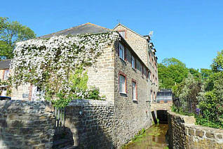
The next highlight is the Mill House and Litton Mill, on the left, with a view into the former yard and then a narrow view up the
leat to the overshot wheel. Main Street then becomes more fragmented, with
a mixture of small older and modern cottages on the right and walls, hedges
and gardens on the left. The chalk stream is evident by the side of the lane,
edged by grassed verges and crossed by brick arched entrance paths to
houses.
The final leg of the route is along School
Lane, marked by the simple Victorian Court
Farmhouse on the junction, modern large
houses and bungalows and the surprising
Thorner’s School, set back in gardens and
play space, with its late C18 front block and
strong Victorian gable ended block attached. There are northward views across the hollow
green centre to the village core with its fine trees, elevated Church, and backdrop of smooth
chalk hills and earthwork lynchets.
Key views and vistas are the series of townscape views from Baglake Farm along Main Street to Whiteway and then up
Church Path; southwards and eastwards at the Chalk Pit Lane/Main Street/Redway crossroads; northwards up Main Street
to the crossroads and a large tree group; from the churchyard south over the village; and from School Lane north towards
the Church.
Landmarks are the Parish Church tower, in the centre of the village; Baglake Farm at the eastern entry; the bus shelter to
the west of Rocks; and the Mill buildings.
Character Analysis
Building Uses
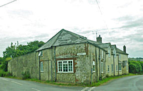
The pre-War village had the expected mixture of Parish Church, Nonconformist Chapel (Methodist, opened in 1873), big
houses (The Court, Old Rectory, Mill House and large farm houses (such as those at
Baglake, Charity, Manor and Barge’s Farms), a corn mill, brewery, forge, school, public
house, farm buildings and cottages. The Poorhouse, on Chalk Pit Lane closed in the
mid C19, replaced by houses, and the Chapel has become part of its former manse, in
residential use. The Mill closed after the Second World War and the shop and other
businesses in the latter part of the C20 (the shop in August 2000). The public house is
relatively remote from the village, to the south at White Cross. There were several
recorded Victorian pubs and alehouses in the centre of the village, now, like the former
Gladwyn Brewery, converted to housing. Several farms in the centre have changed
use, mainly to residential, although Lower Crosstree, on Chalk Pit Lane,
accommodated Moxom’s engineering works (now closed) and Charity Farm’s yard is unoccupied, apart from an adjacent
wheelwright’s premises. The School has seen a number of changes in its status and management and has a large modern
extension and swimming pool.
Building Types and Layouts
The Parish Church shows alteration and additions over time, with a basic plan of west
tower, nave without aisles, south porch and chancel and a Victorian north chapel. The
former Methodist Chapel (Fig. 2) is a small single storey building with a gable end
entry and an attached two storey manse. Thorner’s School (Fig. 2) has a late C18
master’s house and a Victorian and later classroom block at right angles. The house
element is two storey with a symmetrical arrangement of main façade windows and a
central entrance with a porch. It is an interesting example of vernacular survival,
c.1770, still using post- medieval stone mullioned windows and stone coped gables,
possibly one of the latest examples of vernacular survival details in the area. The
symmetrical main façade does, however, acknowledge the ubiquitous school style.
Litton Mill is a mid C19 complex of a three-storey mill block, with an overshot wheel of
1866 and an attached two storey store. The Mill house is contemporary, detached from
the working elements, double pile and central entry in plan. Of the larger gentry houses,
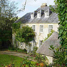
The Old Rectory is a mid C19 two storeys and dormers detached house with, originally, a
central entrance, now off-centre because of a later lateral extension. The main house is
double pile, with parallel roof ridges and there is a rear wing of 1845. Baglake Farmhouse
(Fig. 2) is the largest and grandest house, of five bays with a central doorway. It has older
C17 elements and a large detached single storey barn, as well as a rear courtyard of
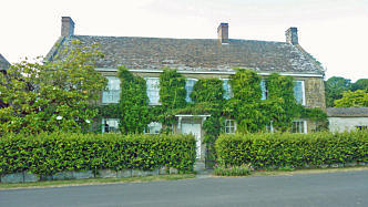
other farm buildings. The Court House is a large detached 1860-ish building with a central
doorway and a pedimented centre and a rear wing and outshuts to north and east. The
Cottage is another mid C19 large house, attached to a row of smaller properties, L-
shaped, with both the main façade and the rear wing having central doorways.
Interestingly, the main block has sash windows and the wing casements, all arranged symmetrically. Charity Farmhouse is
an example of a late C18 detached house (converted into two dwellings), with an off-set entrance (although there is a
blocked entrance to the side of the present door).
There are other larger houses that are attached within rows of subsidiary buildings or smaller cottages. Beech House has a
symmetrical plan, emphasised by its porch. Barges Farmhouse (Fig. 2) is dated 1707 but has a central entrance. Church
Path Cottages are a good example of basically similar cottages, varying subtly in window form and door positions, with both
two and one-and-a-half storey units.
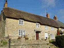
The smaller cottages include the detached Glebe Cottage (Fig. 2), C17, thatched
and with one-and-half storeys, the planning seemingly completely organic; and
many late C18/early C19 attached cottages, in informal rows, thatched or tiled or
slated, both with off-set entrances or central doorways, often single pile in plan.
Brewery Cottages (formerly Barges Farmhouse) has an attached former brewery
(with intact machinery), the house thatched and brewery slated. Nos. 1 and 2
Charity Farm Cottages are an example of
planned semi-detached housing, with entrances
in the flank walls.
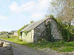
There is a substantial legacy of farm buildings in the Conservation Area, notably single
storey barns at Charity Farm (medieval remains, truncated and later alterations, now three
bays), the western barn at Baglake Farm and a barn with a central cart entrance and
attached, lower shed with a half-hipped (corrugated metal sheet) roof at Lower Crosstree
Farm.
Key Listed Buildings and Structures
There are 28 Listed Building entries, all Grade II apart from the Grade I Parish
Church. The key Listed Buildings are:
Parish Church of St Mary, late C14 and C15, restored in 1878, a major
landmark; there is an attractive churchyard with four Listed table tombs;
The Mill, Litton Mill and bridge spanning the mill leat, a mid C19
ensemble with the wheel extant and channels, leat and overbridge
visible;
The Cottage, mid-late C19, two fine facades, two iron openwork porches;
an interesting example of architectural conservatism, using details of fifty
years earlier;
The Court House, post 1860 grand house with refined Classical details;
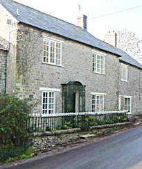
Beech House, early C19, good ironwork Gothick porch and bold railings, important position in centre of village;
The Old Rectory, mid C18 and extensions c.1900, particularly interesting rear wing and outbuildings; set in a sylvan
landscape;
Brewery Cottage, late C18 house and attached former brewery; important in wider group and of industrial
archaeological interest (brewing machinery intact);
Baglake Farm (Fig. 2), C17 and second half of C18, some good quality details and of major group and townscape
value, with its cob and chalk block walls and barn;
Litton Cheney (Thorner’s) School (fFig. 2), late C18 and Victorian and modern additions; attractive vernacular survival
block and Gothic classrooms attached; also of social historical interest because of the Robert Thorner endowment.
Important Local Buildings
The important local buildings are:
Rainbow Cottage, Hine’s Mead Lane, rubble and thatch, a modern example of clever infill that relates well to the Listed
Myrtle and Glebe Cottages; of group value;
Cider barn adjacent to Barges Farmhouse, C19 rubble and slate, two storey, hipped roof, casements; group and
townscape value;
Nos. 1-3a and 4 The Paddocks, stone and slate, brick trim, a short curving row and a detached cottage, all mid C19,
with modern alterations and extensions; group and townscape value;
Nos. 6-10 The Paddocks, a mixed row of cottages, mid/late C19, rubble and brick trim, one brick and stone trim and
one all brick, casements, prominent chimneys and elevated position; group value;
A K6 telephone box by the Whiteway junction;
Court Close, a modern Neo-Georgian large house, of stone, with sashes and attractive ironwork; carefully detailed and
of group value;
Nos. 1-4 Church Path Cottages, a row of attractive thatched cottages, with, largely, informal window and door
patterning and features like eyebrow dormers, important position, elevated above a high stone pavement on the
Whiteway junction; surprisingly unlisted but there is evidence of substantial rebuilding in the concrete lintels;
Nos. 1 and 2 Rectory Cottages, Church Path, mid C19 rubble and brick trim, cambered heads to casements and
simple boarded doors with wooden trellised porch canopies; unspoilt and of group value;
Redway Cottage, early C19, render and thatch, greatly altered by replacement windows but of some historical interest
and group value, at the western crossroads;
Nos. 1 and 2 Groves Cottages, Chalk Pit Lane, latter half of C19, on the site of the Poor House, stone and brick pair,
replaced casements but of group value on the crossroads;
Former barns to Lower Crosstree Farm, Chalk Pit Lane, rubble and tin roofs, two units: higher barn with porch to cart
doors and loop lights and lower shed with half-hip to the lane; of historical interest and group value;
Former Methodist Chapel (fig 3) and attached manse, Main Street, 1873 rendered gable end with two large round-
headed windows and central door, rubble on sides; painted brick house (rubble sides) with sashes; of historical interest
and group value;
Nos. 1 and 2 The Green, next door, C18 rubble and clay tile roof, long and low with a variety of wooden lintel
casements; of architectural and group value;
Two stone sheds on the entrance to Charity Farm, C19, in poor condition but of visual interest;
Stone and pantile former barn south of Waterside, Main Street, C19, with inset cart door; unspoilt example of minor
vernacular building;
No. 1 & 2 Rose Cottages, Main Street, rubble and brick trim, 1886 date stone (refers to conversion from three to two
cottages), hooped and spear railings; group value;
Court Farmhouse, junction of Main Street and School Lane, late C19 stone and brick, cambered heads to casements;
townscape value; the converted former farm buildings to the south
Cheese House, are a group of single and two storey stone, brick and pantile buildings and also have group value;
The 1877 classroom block (Fig. 2) to Thorner’s School, rubble and ashlar, with a distinctive tripartite window in the
gable end; can be seen as being in the curtilage of the Listed master’s house but the List description specifically
excludes it; of visual and social historical value.
Building Groups
The most coherent groups are at the eastern end, from Glebe Cottage to Beech House and attached former shop and forge,
including the Barges Farmhouse row and Brewery Cottage and The Old Brewery on the eastern side of the lane; and in
Main Street, from the former Chapel south to Charity Farm Cottages, including Court House, The Mill and Litton Mill on the
east side.
Building Materials and Architectural Details
The village is situated in an area of varied geology and the most suitable building stone, the Forest Marble limestone, came
from Swyre (thus known as Swyre Stone) and more local quarries at Pins Knoll, to the west, and Looke farm, to the south. It
is characterised as a hard, crystalline, fossiliferous stone, grey in colour and packed with shells. It has a low porosity but is
not easy to work and, although rarely seen as ashlar, it is usually used in roughly squared and coursed rubble form. Its
hardness and resistance to damp make it ideal for foundations and plinths of buildings, pavings and, in some West Dorset
parishes, as roof tiles. The village has an overall grey/blue colour, where modern Portland or Purbeck stones stand out due
to their whiteness.
Some walling has a mixture of colours, with occasional gingery or biscuit coloured stones, suggesting the use of Corallian
limestone, quarried at Baglake Farm. There are orangey ashlar dressings on the Court House, which, from its date of 1860,
may suggest the use of Ham Hill stone or, conceivably, more local Inferior Oolite.
Chalk was locally available, from sources like the appropriately named Chalk Pit Lane. Although soft and porous and
unsuitable for most building work, it has been used as chalk blocks (or clunch), with a suitably more resistant base and
some form of protective capping. This hat and boot construction is seen in the Conservation Area at Baglake Farm’s barns,
Glebe Cottage (Fig. 2) and at the former malthouse. Baglake Farm and Townsend Barn both show the use of Forest Marble
as a base. Thatch was often the original hat, again seen at Baglake Farm. Here, also, the boundary wall immediately east of
the house may be built of cob - chalk, mud, straw and gravel combined to provide a plastic material, again porous but
covered, in this example, with a lime based render and given a stone base and thatch cap. Rough, unknapped flints are also
seen in walling, perhaps as repairs or extensions. Render is also seen on the front of The Old Rectory and the former
Chapel (fig 3), in the latter case, the Forest Marble rubble is evident on the side elevations.
In the latter half of the C19, brick was more commonly used for corner quoins and window and door lintels and reveals, a
logical introduction in an area of stone that is not easily dressed and softer, less weather resistant materials. The Mill house
and Litton Mill buildings are a good example of the mixture of Forest Marble and brick. The whole front façade of one of the
row on the northern side of The Paddocks is built of Flemish Bond, with a wide stone plat band between ground and first
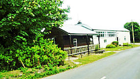
floor. The Parish Hall is built of corrugated metal sheeting, emanating from its first use as an army building.
Boundary walls are important in defining front and side spaces and linking buildings. The typical form is one of Forest
Marble rubble with copings of stones on end or cock-and-hen, alternating tall and short stones. A more refined finish is seen
in the form of a chamfered top, where the individual stones have been dressed. Opposite Redway Cottage is a small space
bounded by flint walls in a curved plan.
Roofs vary between combed wheat and water reed thatch, usually displaying West Dorset rounded, soft forms (simple flush
ridges, eyebrows, undulating eaves lines); clay tiles, pantiles and slate. Thatch usually has gable ends, half-hips or, less
commonly, full hips. There are examples of full stone coped gables (as at Baglake Farm, where the clay tiles are particularly
attractive). The Church’s south porch has clay tiles with scalloped patterning. Dormer windows are rare, seen as hipped
units at The Old Rectory and segmentally arched tops with leaded light casements at Thorner’s School. There are many
examples of eyebrow dormers in thatched roofs, either projecting slightly and creating a subtle waver in the eaves line or set
higher necessitating a bolder rise and fall of the roof. Chimneys are usually of brick, with no great elaboration but there are
some good examples of elaborate octagonal pots in Main Street.
Windows vary greatly according to building age and function. The oldest block at Thorner’s School has raised stone
architraves and mullions. Six over six paned sashes are seen at Baglake Farmhouse (fig 3) and other gentry houses (Court
House has triple sash units on the ground floor with narrower lights flanking a wider central unit) but the ubiquitous type is
the wooden or metal casement, varying from simple wooden types with a minimum of glazing bars to multiple panes,
particularly on metal windows (seen at Cross Trees Farm Cottage, where there are 15 panes per light). Court Cottage (fig 3)
has particularly attractive Colebrookdale (iron lozenge shaped) lights, of three tiers and possibly from Ironbridge. Horizontal
sliding sashes (Yorkshire sashes) are seen at Nos. 1 and 2 Rectory Cottages. Lintels also show interesting variety, from
timber on many cottages, stone with flush keystones at Charity Farmhouse and cambered brick arches on most late C19
buildings.
Doors tend to be of two basic types, the simple vertically boarded form seen on cottages, sometimes with a light at the top,
or multiple panelled examples on more prestigious houses. The panelling may be flush, raised or fielded, with the two top
panels sometimes glazed. Court House has a large plain fanlight over the door, with a stone flat roofed canopy on brackets
or consoles. The Mill has a fanlight with marginal glazing. Doorways have a rich variety of porches and canopies, a
particular feature of the village. Flat timber canopies with brackets may be humble or grand, with very rich volutes on
Baglake Farmhouse. Thatched canopies on brackets or posts are often modern introductions or replacements. There is a
characteristic form of timber porch canopy, seen at Brewery Cottage and Rectory Cottages, with a segmental circular top
and an infill of trellis bars. Iron stays support the former and the latter has trellised timber sides.
There are a number of attractive cast iron and timber enclosed porches, often with tented lead roofs or curved, sheeted
tops, trellised or with Gothic Revival ogees, quatrefoils and tracery at Beech House, diagonal trellis and radial sunbursts at
The Old Rectory and Greek Revival honeysuckle and scrolls at The Cottage (Fig. 2), where there are two porches.
There is an abundance of architectural and less ornate details. The ironwork fleur-de-lis-topped railings and Gothic Revival
gate at Beech House; other examples of spear-topped and hooped railings; the gates, steps and gate piers to the
churchyard and the adjacent piers to The Old Rectory; the boldly moulded and ball topped piers at Court House; the brick
piers and stone pyramidal caps at Barges Farmhouse; the finely lettered gravestone to Reynolds Stone and his wife Janet;
the Millennium sundial on the Church porch; the commemorative bus shelter and Millennium bench by the western
crossroads; and several DCC finger posts, with or without their circular finials (the one at the western crossroads is
complete). There is a stone raised pavement fronting Church Path Cottages, in Forest Marble, and slabs of the same
material at the churchyard entrance steps and by the Church porch. There is also an area of pebbles set around the base of
the Church. Rocks, the path from the Church west to the bus shelter has several distinctive wooden stiles with rotating arms.
There is an unusual boot scraper by the Church porch (Fig. 2) with griffin uprights. South of Court Farmhouse, in Main
Street, there is an iron lamp overthrow and a gate with fleur-de-lis and hooped finials.
Parks, Gardens and Trees
There is no parkland as such but the large green hollow of undeveloped farmland north of School Lane is of great landscape
value. The most significant large garden is that of The Old Rectory, with two large ponds and copious planting of native and
ornamental trees. It has connections with the artist Reynolds Stone and is a great asset to the village both in long views and
from the Rocks path and the western crossroads. The village is characterised by smaller cottage gardens, in small front and
side spaces and, where front boundaries are minimal, as wall climbers and shrubs planted almost on lanes. The main east-
west lane, The Paddocks and Main Street have seasonal colour and texture that complements the buildings.
Although the village is richly enhanced with groups of mature trees and individual specimens, there are few Tree
Preservation Orders (TPOs), with the three exceptions of the hedge and tree belt up Whiteway, a small group on the eastern
edge of the churchyard and two individual designations on the southern boundary of The Rectory. Apart from these, the
main tree groups are east of Baglake Farm; around Glebe Cottage; a strong southern boundary from Glebe Cottage to
Beech Cottage and on the east side of Hine’s Mead Lane; south of Skep House, The Paddocks; in the churchyard and
along the northern boundary of Church Path and Rectory Cottages; up Whiteway; the grounds of The Old Rectory; on Chalk
Pit lane west of Garden Close; down Main Street on the boundary of Court House, in its grounds and behind Faith House
and The Mill; and east of the School in School Lane. There are important individual trees, exemplified by the beech on the
grassed triangle by the Whiteway junction.
There are also a number of important hedgerows: on the southern side of the lane opposite Rose and Redway Cottages;
and on School House and Hine’s Mead Lanes.
Detrimental Features
Wires and poles around the western crossroads;
The visual intrusion created by the large modern shed at the former Moxom’s works;
The loss of details through replacement of doors and windows on several unlisted buildings of character, mainly later
C19 cottages;
The parlous state of the Listed barn at Charity Farm, categorising it as a Building at Risk;
Some weak boundaries on modern infill development that would benefit from additional hedge and tree planting, for
example, along Chalk Pit and School Lanes.
Definition of the Special interest of the Conservation Area
A high quality landscape setting, within the Dorset AONB, positioned on the slopes of a chalk escarpment and the
valley of the River Bride;
Set in a well-treed local landscape, with hedgerows on the main approaches, small woods and areas of ornamental
planting in the village core;
A fairly intact plan and some well defined boundaries on the eastern and southern sides of the village and an important
undeveloped green heart in the centre;
28 Listed Building entries, including a Grade I Parish Church, several important larger houses, vernacular smaller
cottages, the shell of a C19 watermill and a C18 core of Thorner’s School;
About 20 buildings or groups of unlisted buildings of value, notably the former Chapel, Victorian School block, a K6
telephone box, former sheds and barns and C19 cottages;
Several coherent groups of Listed and unlisted buildings, boundary walls and trees, particularly at
Local building materials, notably Forest Marble and Corallian limestones, chalk block and cob and thatch, together with
many other details, such as ironwork, gate piers, commemorative stones and structures, paving and sign posts that
add to the quality of the Conservation Area and the local distinctiveness of the village.


Entrance to Whiteway
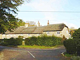
Barges Farmhouse, Randell & Barges Cottages
Barns at Charity Farm entry 2007
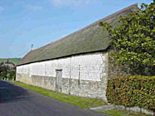
Barn at Baglake Farm
Church Path Cottages
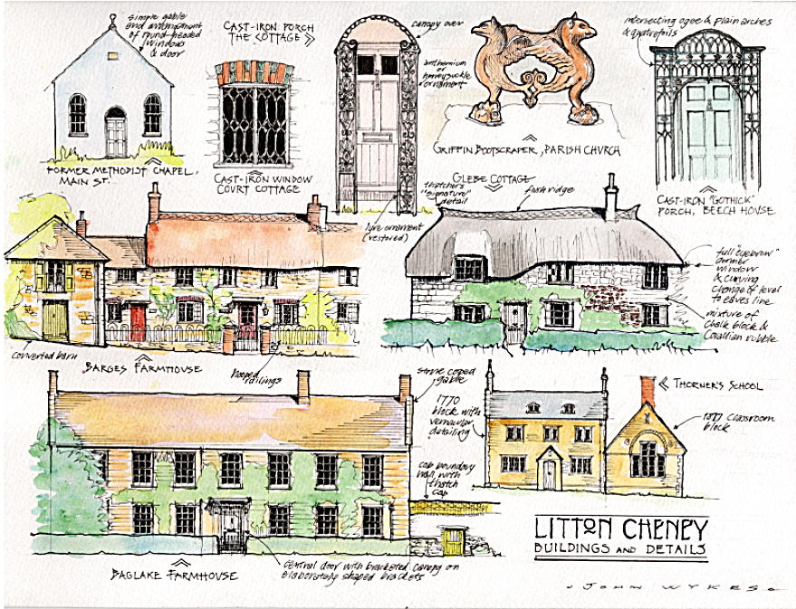
Figure 2 - Details of Buildings
Beech House
Main Street
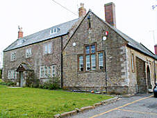
Thorners School
In December 2007, following public consultation, West Dorset District Council published an appraisal describing the special
architectural and historic features of Puncknowle, Burton Bradstock, Litton Cheney, Winterbourne Abbas and Shipton
Gorge conservation areas. The stated intent was “to produce a document that supported conservation area policies in the
West Dorset, Weymouth and Portland Local Plan“ (adopted 22 October 2015).
The following is the section covering Litton Cheney. The text is unchanged but the photos have been supplemented and
re-arranged to suit the web page layout.
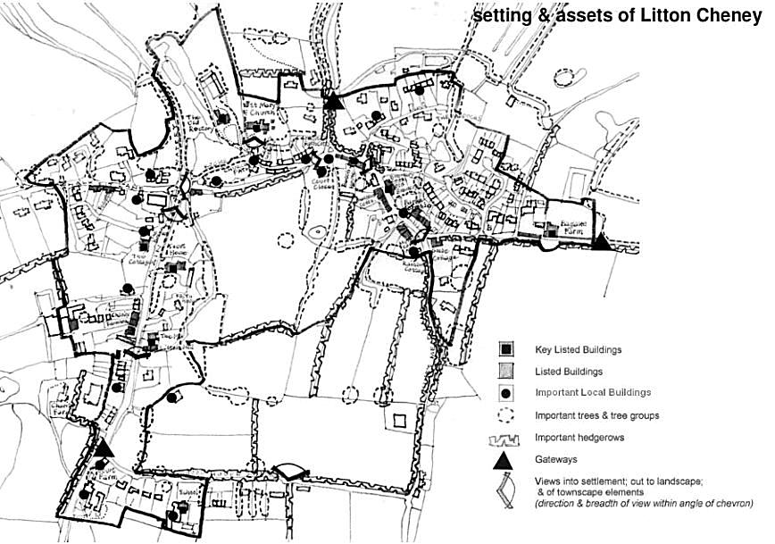
Figure 1 - Setting and Assets

Outline of Conservation Area
White Cross
Youth Hostel
Glebe Cottage
Old Rectory
St Marys Church
Baglake Farmhouse
Litton Mill
The Mount
Rocks Footpath
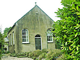
Te Old Methodist Chapel
Baglake Estate
Dorset
Village Information v
Local Amenities v
Village Amenities v
ABOUT LITTON CHENEY

OUR VILLAGE - WDDC APPRAISAL 2007

ABOUT LITTON CHENEY