This section of the website is not intended to be a comprehensive history of Litton Cheney. The intention is to form an archive of any
historic matter which is relevant to the village and its people.
Material will be gratefully received from any source, with a view to preserving it before it is lost forever and making it available to as
wide an audience as possible. This may be in the form of photographs, hand written material, verbal anecdotes, references to
published material for which official right to publish can be obtained, etc.
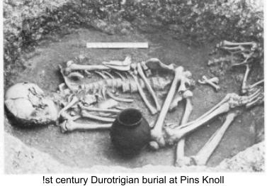
The origins of Litton Cheney go back to the Iron Age and Romano-British settlements. The best evidence for this comes from the
excavation of Pins Knoll by C. J. (Jack) Bailey, a former headmaster of Thorners School, at various times between 1958 and 1974.
Pins Knoll is a flat topped spur jutting out into the Bride Valley at the top of
Chalk Pit Lane. Excavations showed that a settlement, dating from the early
Iron Age, had occupied the site for nearly a thousand years. Pottery finds
ranged from the red-coated wares of the first Iron Age, through the typical black
vessels of the Durotriges to the black burnished coarse ware and fine imported
pottery of the Roman period.
Other finds included wheat grains, animal bones, stone loom weights, sling
stones and the vertebra of a whale. Evidence of the Roman Occupation
included coins, pottery and brooches.
Of particular note is a coin attributed to the German king Lothaire II (855-69).
More details here.
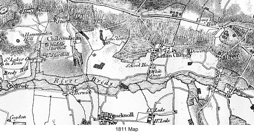
The earliest documentary records of the Bride Valley date from 987 AD, when it
was named as a religious offshoot of Cerne Abbey. Few records exist from this
date until the extensive detail provided by the Domesday Survey of 1086.
This shows that the parish of Lideton, which contained the village we now know as Litton Cheney, consisted of three distinct parts.
An isolated area north of Oscherwille (now Askerswell), shown in parish records as Loderland, reached as far as Eggardon Hill. To
the south a triangle formed by Parks Farm, Gorwell and Ashley stretched from the River Bride to the boundary with the parish of
Abedsberie (now Abbotsbury). The central section stretched from the River Bride northwards to the Roman road linking Dorchester
and Bridport. These boundaries remained much the same until 1889 when the basis of those we know today was established.
The 13
th
and 14
th
Centuries
The village is not specifically mentioned in the Domesday record, but was certainly well established by then and may well be the
unnamed manor of 10 hides in the Hundred Uggescombe, listed under the lands of Hugo de Boscherbert. The name probably has
its origin in the Old English ‘hylde’, meaning a fast running stream and ‘ton’, a farm or manor. By the 13
th
century the manor was
known variously as Lideton or Ludeton but by the 14
th
century the
name Litton had evolved.
Around 1236 the manor was purchased by the de Gorges family
from Normandy. The manor house was most likely where the
Court House is today - the banks of its fishponds can still be seen
in Court Close. In 1304 one of the de Gorge grandsons was
granted a weekly market at the manor of Lideton, Co. Dorset and a
yearly fair was held there on the Virgil and Feast of the Nativity and
six days following (7
th
-14
th
September). In 1316 the manor is
referred to as Lutton Gorge.
After 1339 the de Gorge family found themselves without a male
heir so, over several generations, the manor was divided up until it
was eventually split between Sir Morys Russell of Kingston Russell
and Sir Ralph Cheney. They agreed to share the advowson of the
church but Sir Ralph became owner of the demesne manor. Thus,
from then on, it was known as Litton Cheney – it could so easily
have been Litton Russell!
The 15
th
,16
th
and 17
th
Centuries
By the time of Queen Elizabeth the 1
st
, the old divisions of the de Gorges manor are still evident. The Prowtes occupied the farm
and manor house; the rest of the land being held by the Hodders and Hurdings. By the end of the 16
th
century, however, the
Hurdings, who lived in Long Bredy, had taken over the manor, letting it out to various tenants right through to the beginning of the
18
th
century.
The 18
th
,19
th
and 20
th
Centuries
In 1712 the Hurding’s property was bought by George Richards of Long Bredy. With the manor went the right to present to the
church so his grandson became the parson at Litton. With the death of the Rev.
John Richards in 1803 the whole of the Richard’s property was sold. Litton was
bought to be divided up into smaller units and re-sold to create smaller farms.
The manor was now reduced to 130 acres and this, together with the rights and
privileges that went with it, was bought by the Rev. James Cox. Thus, he and
his son John, both rectors at Litton, were the last traditional lords of the manor.
At this time the Court House went with Court Farm, which had been formed out
of the old manor lands. Job Legg who, at the end of the 1700s, was the tenant
of it under the Richards family, bought 370 acres and with them the old Court
House. Today’s Court House was built by one of his descendants, Benjamin
Legg, on the site of the old one which was destroyed by fire around 1860.
Since then all the farms except one have disappeared with much changing of
owners, re-distribution of fields and housing development so that today there is
no dominant landowner.
OBJECTIVE OF ARCHIVE
In 1870-72, John Marius Wilson's Imperial Gazetteer of England and Wales described Litton Cheney like this:
LITTON-CHENEY, a village and a parish in Bridport district, Dorset. The village stands 4 miles SE of Powerstock r. station, and 5½
E by S of Bridport; was once a market-town; and has a post office under Dorchester. The parish contains also the hamlets of
Nether Coombe, Higher Egerton, Ashby, and Stancombe. Acres, 3,817. Real property, £ 4,713. Pop., 501. Houses, 99. The
property is divided among a few. The living is a rectory in the diocese of Salisbury. Value, £800.* Patron, Exeter College, Oxford.
The church is ancient and good, with a tower; and contains an ancient font, a monument of the Dewberry family, and several
brasses. There are an endowed school with £25 a year, and charities £7.
Footnote:
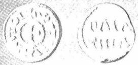
Diameter 15 mm Weight 0-73 gm. Die-axis 90°
The coin is illustrated here by greatly enlarged photographs of plaster-casts, and it is thought to be unlikely in the extreme that any
will wish seriously to challenge the following interpretation of the legends. The find-spot and the circumstances of discovery are
sufficiently indicated in the following note which we owe to the kindness of Mr C. J. Bailey of The School House, Litton Cheney, who
actually found the coin in the course of archaeological excavation.
“Trial excavation of the relatively flat area of Pins Knoll above the lynchets was carried out in 1959 when the site was established as
that of an 'open farm' of the Early Iron Age with a possible continuation into the Romano-British period. It was discovered and
established by the writer in time to be included on the Ordnance Survey Map of Southern Britain in the Iron Age. Further work this
year has confirmed that occupation continued at least until A.D. 350. The coin was found at a depth of eighteen inches and a few
inches above the 'fall ' layer associated with a Romano-British building tentatively dated A.D. 300. Subsequent disturbance has
made stratification difficult, but a section at a point near where the coin was found suggests a relatively shallow build-up in post-
Roman times underlying a deeper layer resulting from medieval ploughing. One finds it difficult, therefore, to divorce the coin from
early cultivation of the lynchets, although today no other material has been found which might be in any way associated with it. The
coin was excavated personally by the writer and the most striking thing would seem to have been its extraordinary good state of
preservation. It hardly needed washing.”
From the above it should be clear that the circumstances of the coin's discovery, though seeming to establish authenticity beyond all
cavil, throw little light upon the problem of its attribution. It can be said, though, that there is a presumption that such an obolus
belongs to a ninth-century Lothaire rather than to one of the tenth-century princes of the same name. As is well known, a feature of
post-Alfredian legislation was its insistence that foreign money should not circulate within the dominions of the English king, and
more than one recent paper has stressed just how few are the tenth and eleventh century coins from the Continent that can be fairly
associated with finds from the English kingdom proper. The fabric of the new obolus, too, is one that cries out for a ninth-century
attribution and for a place of minting north of the Alps, and we ourselves have no hesitation whatever in assigning the coin to the
German king Lothaire II (855-69), while the greater probability is that the mint is to be identified as Aachen (Aix-la-Chapelle). Even
denarii of this king and mint are notably rare and the obolus was hitherto unknown. However, we should observe that this would not
seem to be the first time that coins of the king have been recorded with an English provenance. How the obolus from Pin's Knoll
arrived in England and how it came to be lost on a lynchet in the vicinity of the, as yet precisely to be identified, site of the Alfredian
burh in ‘Brydian' are questions to which answers may never be given.
Coin Found on Pins Knoll
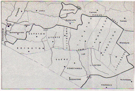
Parish Boundaries at the time of the Domesday Survey
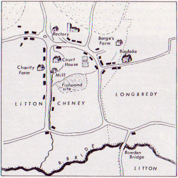
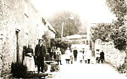
Litton in the early 1700s

HISTORIC ARCHIVE
Early History
LITTON CHENEY CENSUSES
A census is taken every 10 years. Those currently available for public viewing cover the period 1841 to 1911 – data is only made
available after 100 years have passed. Each household is required to complete a census return on a particular night. Thus, it merely
provides details of who was present on that day, not necessarily of everybody who normally lives there. The data requested varies at
each census, more information being available from the later ones. However, except for major dwellings such as the church, the
school, larger houses and farms, there is no record of the actual location of each dwelling.
The boundaries of Litton Cheney Parish have been manipulated at various times during the period covered by available census data.
The following lists are taken from the introduction of each census.
1841 - gives no schedule numbers, no indication of relationship and the ages over 15 years are rounded to the nearest five
years. There is no description of the area covered.View transcription
1851 - Covers the whole of the Parish of Litton Cheney including Loder Lands Farm, Eggardon, Stancombe Charitys, Gorwell, Ashley, Parks and
Litton Cheney Village.View transcription
1861 - Covers the whole of the Parish of Litton Cheney including Loder Lands Farm House, Eggardon Farm House, Dairy House and Cottages,
Stancombe Cottages, Combe Farm House, Dairy House and Cottages, Litton Cheney Village and Charitys, Parks Dairy House, Ashley Dairy
House and Cottages, and Gorwell Farm House and Cottages.View transcription
1871 - Covers the whole of the Parish of Litton Cheney including Litton Cheney Village, Loder Lands Farm Houses, Eggerton, Stancombe,
Charitys, Gorwell, Ashley, Parks, White Cross and Combe Farm House and Cottages. View transcription
1881 - The whole of the Parish of Litton Cheney including Litton Cheney Village, Loder Lands Farm Houses, Eggerdon Farm House
and Cottages, Stancombe Cottages, Charitys, Gorwell Farm House and Cottages, Ashley Dairy House and Cottages, Parkes Dairy-
House, White Horse, Coombe Farm House and Cottages.View transcription
1891 - The whole of the Parish of Litton Cheney is bounded on the West by Chilcombe, on the North by Askerswell, on the South by
Puncknowle and on the East by Abbotsbury.
It includes Litton Cheney Village, Stancombe Cottages, Gorwell Farm House and Cottages, Ashley Dairy House and Cottages,
Parkes Dairy House, the White Horse Inn and Coombe Farm House and Cottages. Unfortunately the census document does not
show addresses.View transcription
1901 - The whole of the Parish of Litton Cheney is bounded on the West by Chilcombe, on the North by Powerstock and the Old
Roman Road, on the South by Puncknowle and Swyre and on the East by Long Bredy.
It includes the Parish of Litton Cheney, Stancombe Cottages, Coombe Farm House and Cottages, the White Horse Inn, School
House and Cottages. Unfortunately the census document does not always show addresses.View transcription
1911 - The whole of the Parish of Litton Cheney is bounded on the West by Chilcombe, on the North by Powerstock and the Old
Roman Road, on the South by Puncknowle and Swyre and on the East by Long Bredy.
It includes the Parish of Litton Cheney, Stancombe Cottages, Coombe Farm House and Cottages, the White Horse Inn, School
House and Cottages.View transcription
Occupations
The table below summarises the occupations of Litton Cheney residents during the period covered. As one would expect, the
majority were involved with various types of farm-work. However, many now defunct (as far as the village is concerned)
occupations are listed e.g. cordwainer, brewer, baker, harness maker and, in particular, servant.
**Note:
1901 and 1911 scholar totals estimated from children’s ages i.e. 5 to 13 which was the
compulsory period for education, although difficult to enforce. In 1841 there were 70+
children between the ages of 5 and 13 but no compulsory education.
Families
It is interesting to see how many names crop up during the period covered. Some families appear on as many as seven censuses
and may continue after the 1911 version. The table HERE lists those that appear on at least two censuses.


1841
1851
1861
1871
1881
1891
1901
1911
Farmer
7
7
10
9
8
8
6
11

Agricultural Worker

47
78
66
117
47
77
26
47
Carter/Carrier
7
12
19
19
2
11
8
Cattle/Corn Dealers
1
1
Dairy Worker
7
9
23
16
12
18
13
7
Gamekeeper
1
1
2
1
2
2
1
Shepherd
4
6
10
7
7
1
6
1
Waterman (Water Meadows)
1
2
Woodman/Hurdle Maker
1
1
3
7
2
2
Total Farmworkers
75
114
135
157
98
110
64
74
Annuitant/Fundholder/Pensioner
4
2
11
3
Bailiff
2
1
1
Baker
3
4
7
2
6
7
5
8
Blacksmith
4
4
4
3
1
3
1
3
Brewer
1
1
Bricklayer
1
1
2
Builder
1
1
1
Butcher
1
2
1
1
1
Carpenter/Wheelwright
10
7
7
6
7
2
3
4
Charwoman
5
6
3
5
3
Coachman
1
2
1
Cordwainer/Shoemaker
6
6
6
4
4
3
4
2
Dressmaker/Seamstress
1
4
8
7
4
6
4
4
Engineer
1
2
1
Gardener
1
1
2
3
4
1
3
Grocer
1
2
2
4
3
2
4
Groom
3
3
4
1
2
Harness Maker
1
Independent Means
8
4
4
4
8
4
2
Labourer
3
1
4
3
1
2
3
Landlord of White Horse Inn
1
1
1
1
1
1
1
1
Laundress
1
2
5
3
4
2
Maltster/Brewer
2
1
Mason
3
6
4
4
3
4
1
Miller
2
3
2
1
3
2
1
Net Braider
8
27
13
9
1
4
3
Pageboy
1
Pauper
4
11
3
2
2
Post Master/Mistress
1
1
1
2
3
Primitive Methodist Preacher
1
Rector of St Mary’s Church
1
1
1
1
1
1
1
1
Roadman
6
2
3
2
1
1
Scholar
?
37
67
130
78
49
59**
49**
Schoolmaster/Schoolmistress
1
2
3
4
3
2
2
6
Servant
24
22
17
19
13
13
6
7
Solicitor
1
Thatcher
5
3
3
1
2
1
1
Washerwoman
1
1
1
Watch & Clock Maker
1


Occupation
THE PASSING YEARS
The following are links to newspaper articles covering various aspects of life in Litton Cheney over nearly 200 years. Plus ça
change, plus c'est la même chose!
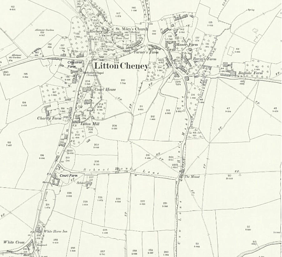
1902 Map
Life and Death
Deeds and Mis-deeds
Life in Wartime
Paul Kingston has compiled the following diaries covering every-day life in Litton Cheney during the First and Second world wars:


Village Information v
Local Amenities v
Village Amenities v
About Litton Cheney v
Dorset Council v
Parish Council v